
Natural Solutions
What are natural solutions?
There are many terms that are used interchangeably by professionals and the public to refer to ‘natural’ efforts to reduce flood risk including ‘natural solutions,’ ‘nature-based solutions,’ ‘natural flood management,’ ‘sustainable flood management,’ ‘working with nature,’ ‘nature-based features,’ and ‘engineered with nature.’ While all these terms share similarities, there are also relevant distinctions between them. Within the Scheme, the Project Team refers to these ‘natural solutions’ as Nature-based Solutions (NbS), Natural Flood Management (NFM), Sustainable Flood Management (SFM) and Blue-green Infrastructure.
Nature-based Solutions (NbS) are a way of solving a variety of society’s problems by working with natural processes. It does this by protecting, restoring, or improving ecosystems. NbS often focuses on enhancing biodiversity, which means increasing the variety of plant and animal species in an area. Some examples of NbS include removing carbon dioxide from the atmosphere (known as carbon sequestration), or sustainable management of forests and wetlands.
Natural Flood Management (NFM) is a specific type of NbS that manages the sources and pathways of floodwater on a catchment scale. The aim is to reduce the risk of flooding downstream. Examples of NFM include river meandering, online storage, offline storage, and tree planting. Although NbS and NFM use natural processes, they are still engineered solutions to address the challenges of society.
Sustainable Flood Management (SFM) is the reduction of flood risk to downstream receptors through the sustainable use (and reuse) of the natural and built landscape, and its raw materials. Examples of SFM include using existing assets such as reservoirs, or offline ponds to store water in the catchment.
Blue-green infrastructure refers to a network of natural or nature-inspired features which operate similar to more engineered alternatives, but with added environmental benefits.
Including Natural Solutions in the Scheme
The Scheme has always sought to include ‘natural solutions’ within its design.
The Scheme is currently within its Project Stage 4 and is developing an Outline Design which will be presented to council in January 2024. This Outline Design still contains the significant Sustainable Flood Management measures that were originally included in the ‘Preferred Scheme’ in January 2020. These include:
- The modification of Rosebury Reservoir to store large volumes of water during a flood event;
- The modification of Edgelaw Reservoir to store large volumes of water during a flood event;
- The provision of a new large debris catcher by Whitecraig.
By implementing these sustainable measures in the catchment, the need for high flood defences within Musselburgh can be reduced and no changes would be required to the Roman Bridge and Rennie Bridge. This is due to the reduction of peak flow these measures provide during a flood event.
Following the Cabinet meeting in January 2020, the Project Team had explored the potential for additional ‘natural solutions’ in the catchment through several means:
- Engaged the Scottish Government’s NFM Research Project Team who are delivering the Eddleston Water project;
- Developed a partnership working arrangement with Dynamic Coast, who are a new governmental organisation tasked with developing an understanding of Scotland’s Coastal Change;
- Engaged with individuals and organisations across the River Esk catchment to identify potential new NFM options that could be included for delivery within the Scheme;
- Development of the parallel new Musselburgh River Restoration project following instruction from council in August 2022;
- The Project Team also brought to council in October 2023 the scientific report called Lessons Learned about Natural Flood Management from the Eddleston Water project for council to read and debate.
Please see below reports undertaken by Jacobs regarding Natural Solutions for the Scheme.
An Environmental Impact Assessment (EIA) is currently being progressed for the Scheme. The EIA assesses the impact of the Scheme’s design on the environment and will consider a variety of factors from proposed location of the works, to materials used, the impact on human health, ecology, biodiversity, the water environment, cultural heritage, traffic and much more. As part of this, consideration will be given to any further NFM or NbS.
Thanks to your feedback provided over years of consultation, ‘natural solutions’ are now a central part of the Scheme’s Outline Design. You can see what natural solutions have been included so far in the design in the infographic below.

Lessons learned about Natural Flood Management from the Eddleston Water project
On March 30th, some of our Project Team, accompanied by a selection of Musselburgh stakeholders and the Eddleston Water project team, visited the Scottish Government’s national NFM research project on the Eddleston Water, near Peebles.
The Eddleston Water project was established in 2009 by the Scottish Government, Tweed Forum, Scottish Borders Council, SEPA, and the University of Dundee. It was created to assess the effectiveness of NFM as a means of delivering flood risk reduction and habitat improvement on a catchment scale.
The Eddleston Water catchment is 69km2 in size, and the measures implemented by the project include:
- Planting 330,000 native trees
- Constructing 115 high-flow log structures
- Re-meandering 3.5km of river channel
- Constructing 38 flood storage ponds
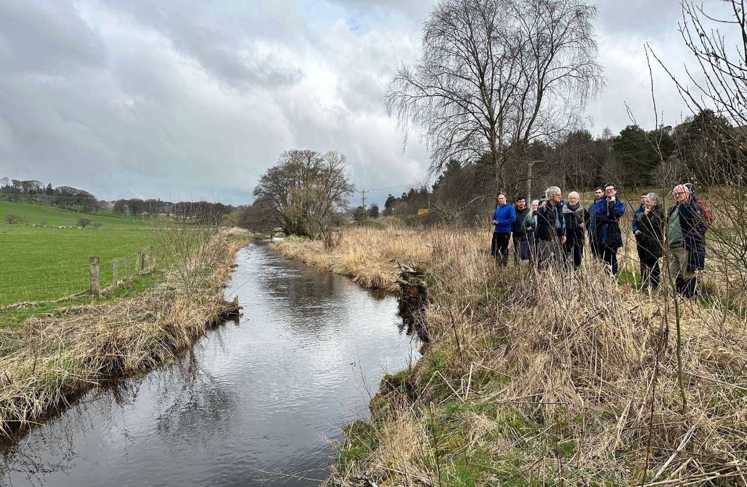
During the visit to Eddleston Water Project, the Project Team received valuable scientific insight on the use of NFM and NbS within flood protection schemes. This advice highlighted that:
- NFM is most effective against small flood events on small catchments;
- NbS is not necessarily NFM, however NFM options typically deliver excellent NbS outcomes;
- NFM should be seen as complimentary to more traditional forms of flood protection, rather than an alternative. Utilising both will likely deliver the most effective outcomes;
- NbS and NFM projects still require design, engineering, and delivery, usually through construction activities;
- It was also noted that NFM options may involve cutting down trees, however this is often done so that they can be repurposed or help transform the landscape.
The independent research conducted by the Eddleston Water Project Team showed that NFM works best for small flood events in small catchments, reducing the peak flow by up to 5%. The project demonstrated that some NFM measures did reduce the flood risk to downstream areas while others did not make a clear difference although they did enhance biodiversity.
To avoid the need for physical defences in Musselburgh, a 50% reduction in the flow of the River Esk would be required to protect against the town’s present-day risk of a flood event. This reduction is before any additional risk of climate change is considered.
Musselburgh’s present-day flood risk has a 0.5% chance of occurring in a twelve-month period.
Increasing the effectiveness of ‘natural solutions’ tenfold to achieve the river flow reduction is not simply a matter of planting more trees and restoring more peatland. There are practical limits to how much land in the catchment can be acquired for this purpose.
Design Consultant, Jacobs, produced a report on behalf of the council called, Lessons Learned about Natural Flood Management from the Eddleston Water project. This report is based on several references including the independent research reports produced by the Tweed Forum and the University of Dundee on behalf of the Eddleston Water project, as well as ‘lessons learned’ based upon those report findings and the knowledge gained through the site visit to the project.
Please click the link below to read the report by Jacobs.
Natural Flood Management (NFM)
Musselburgh’s flood risk from a present-day 0.5 AEP event on the River Esk would require approximately a 50% reduction in peak flow to avoid the need for physical defences in the town. As such, NFM is not an alternative to engineered solutions, but could be complimentary to them.
A 5% reduction in the flow of the River Esk could reduce the required height of physical defences in some parts of Musselburgh by approximately 100-150mm. Alternatively it could help offset future increases in flood risk due to climate change.
The science of quantifying flood risk reduction from NFM is still in its infancy. The uncertainties associated with this present risks which are unacceptable to the Council and, if included within the Scheme, could jeopardise its successful delivery. We are proposing an upper catchment debris trap and the adaption of two Scottish Water reservoirs as part of sustainable flood management. We therefore propose that NFM measures in the catchment should be considered further, independently of the Scheme, and as part of a national commitment to furthering NFM. As the certainty around the science improves, this could contribute to a long-term managed adaptive approach in response to future increase in flood risk to Musselburgh.


Sustainable Flood Management (SFM)
Sustainable Flood Management (SFM) means using and reusing the natural and built landscape to lessen the risk of floods downstream. In the South Esk catchment, the Scheme is proposing to minimise flooding in Musselburgh through major sustainable interventions.
The ‘Preferred Scheme,’ which was the concept design presented to the elected members in January 2020, proposed several SFM options. These have been developed further within the Outline Design and negotiations remain ongoing with the relevant landowners.
Within the Outline Design, the Project Team are proposing the following SFM measures:
- Modification of Rosebery reservoir and Edgelaw reservoir so that they store floodwater during a flood event and reduce the peak flow in the River Esk.
- Construction of a debris trap on the River Esk, at Cowpits near Whitecraig, to reduce the risk of large tree trunks being washed downstream during a flood event, leading to blockage or damage to the Olive Bank Road Bridge, Roman Bridge, or Rennie Bridge.
- Replacement of the Ivanhoe Footbridge, Shorthope Street Footbridge, Electric Bridge and Goosegreen Footbridge to remove their in-stream piers and raise their deck levels, thus reducing their restriction to flow of the River Esk during a flood event.
Early discussions with Scottish Water determined that only two reservoirs, Edgelaw on the Fullarton Water and Rosebery on the River South Esk, were suitable for modifications to increase their capacity for storing flood water.
The design involves lowering the normal level of the reservoirs by 2m, which is achieved by adding a new control structure to the existing reservoir. These changes will allow the reservoirs to store more water during storm events which, in turn, will reduce the peak flow water along the downstream end of the River South Esk and thereby in the River Esk in Musselburgh.
Another concern is the risk of large tree trunks being carried downstream during floods and potentially blocking or damaging Olive Bank Road Bridge, the Roman Bridge, and / or the Rennie Bridge. To address this, the Scheme proposes installing a debris catcher (trap) on the River Esk at the Cowpits near Whitecraig. This will significantly reduce the risk of large debris blocking the bridges in the town.
By implementing these sustainable measures in the catchment, the need for high flood defences within Musselburgh can be reduced and no changes would be required to the Roman Bridge and Rennie Bridge. This is because these measures reduce the peak flow water by 8-10%. This is almost double what Eddleston style NFM would be capable of achieving to protect Musselburgh.


River Restoration
Within Musselburgh’s conservation area, between Olive Bank Road Bridge and the mouth of the River Esk, the banks of the river have been heavily modified by engineering works. This occurred between the 1850s and the 1950s, much of which was likely in response to the major flood event in 1948. The result is an unnaturally wide channel which is artificially straight, with minimal vegetation along the water’s edge and mown grass on the riverbanks. This landscape has limited biodiversity and is poor at responding to changes in river flow.
The river channel in its current form is broadly capable of containing up to the 10% AEP (1 in 10 year) flow, depending upon the tidal level in the Forth Estuary at the time. This is one reason why Musselburgh does not have a history of smaller flood events in recent decades.
During the Scheme’s consultations, the public asked for more natural solutions to the town’s challenges, so in response the elected members instructed the Project Team to develop the Musselburgh River Restoration project. As a multiple-benefit to the Scheme, where possible, this aims to return the riverbanks and riverbed of the River Esk to a more natural condition.
Creating a more natural river channel has many benefits:
- A greater diversity of flow across the width of the river, which benefits fish and other wildlife.
- Provides greater shade along the water’s edge, which benefits fish.
- Improves accessibility between the riverbanks and the riverbed for wildlife.
- Enhances the biodiversity of the river.
- Creates a more natural environment which promotes people’s health, happiness and wellbeing.

Musselburgh River Restoration would be taken forward as a multiple-benefit of the Scheme incorporating measures such as:
- Removing some structures from the water’s edge and replacing them with natural alternatives.
- Reforming certain stretches of riverbank to improve connectivity with the riverbed.
- Introducing a greater variety of planting along the water’s edge.
- Managing areas of sediment deposition and erosion to encourage the river to adopt a more winding and natural flow path during periods of low flow.
The design currently proposes to reprofile parts of the riverbank from Olive Bank Road to the Roman Bridge to restore a more natural form with riparian plantings and biodiversity enhancement, blending into the new flood defence. Biodiversity enhancements are also planned down the river on Eskside West where flood defence embankments are proposed.
Blue-green infrastructure
Most of Musselburgh’s road drainage discharges, together with foul connections, to a ‘combined’ sewer network which is operated and maintained by Scottish Water. During intense rainfall, the capacity of this network can be exceeded, resulting in ponding on roads. While this may be unpleasant, the flood risk to properties is relatively low.
The Outline Design includes blue-green infrastructure to minimise any further pressure on the road drainage in addition to the proposed new surface water pumping stations. Swales are man-made, shallow channels covered in vegetation. They will be used to intercept runoff water and encourage infiltration or drainage back to the river.
Looking to the future of NFM in Musselburgh
The Scheme is being designed during a period of substantial change in our understanding of the emerging Climate Crisis, and its Climate Change Policy. The Scheme has also fully considered the new (and substantially greater) climate change projections deriving from UKCP18.
Musselburgh cannot have its flood risk completely removed as the town will continue to remain on the natural flood plains after the Scheme is delivered. Unfortunately, there will always remain a risk of a larger flood event than the Scheme protects against, and all indications are that climate change will make future flood risks worse.
The Project Team advised East Lothian Council during a meeting of full council in October 2023, that continued work on natural flood management in the River Esk catchment will be the best way to continue to reduce that future flood risk once the Scheme is completed.
It was proposed that NFM measures in the River Esk catchment should still be investigated further and contribute to a long-term managed adaptive approach in response to future increase in flood risk to Musselburgh. It is intended that these measures are delivered independently of the Scheme so that timescales associated with the achieving landowner agreement and baseline monitoring do not delay the Scheme’s ability to proceed with protecting Musselburgh from the present-day flood risk.
The Tweed Forum was key to the successful delivery of the Eddleston Water project, and without them no NFM measures would have been implemented. This is because they acted as an ‘honest broker’ between the project and individual farmers and landowners. Not only did their knowledge of farming practices and individuals provide essential understanding of what measures and locations would be acceptable, they also were able to reach agreements voluntarily on a basis of trust.
The Project Team propose similar for East Lothian Council and the formation of an independent body, like the Tweed Forum, for the Esk catchment. This will enable the capability of this body to engage landowners to broker agreements between them and the council to deliver NFM in the Esk catchment.
The Scheme continues to seek to deliver as many other positive outcomes as possible in the catchment, within the river corridor in Musselburgh, and along Musselburgh’s coastline. This includes biodiversity enhancement, fish passage improvement, increased water quality and habitat creation. This approach is consistent with the ethos of Scotland’s recently published National Planning Framework 4 (NPF4).